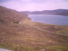
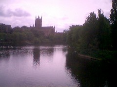
 Day 21 May 31st Uig
Originally uploaded by rhesus42.
Day 21 May 31st Uig
Originally uploaded by rhesus42. Wednesday, May 31, 2006
Day 21 May 31st Uig
Day 21 May 31st Uig
Originally uploaded by rhesus42. Tuesday, May 30, 2006
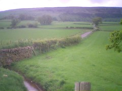
Day 20 May 30th - Broadford
Today's Track
Today's picture is of the Jacobite, the daily steam service that runs from Fort William to Mallaig along the West Highland line. The locomotive is being fuelled and watered.
I shouldn't have been able to take this picture. The train does not arrive in Mallaig until lunch time. By then I should have been well on my way to Elgol, on Skye. However, at breakfast, my hosts in Mallaig reported that all Skye ferry sailings for the day had been cancelled. The ferry had engine trouble. This was a bit of a blow, since my entire itinerary was based on making it onto Skye today. The couple who were hosting me in Mallaig were very familiar with the workings of the ferries. It turns out that he had recently retired as port manager for the ferry company. A phone call confirmed that there would be a sailing later in the day using a different ship. It meant that I would be able to get to my next stop in Broadford but that I would have most of the day to kill in Mallaig. After buying a ticket to make sure I would get on the sailing, I mooched around Mallaig, trying to stay dry and getting a few photos. Checking at the station, I discovered that the Jacobite had just started its service for the season, and that it would be arriving at lunch time. So that was one hour taken care of. While I was photographing the harbour, Luc cycled into town. He also was looking for a ferry to Skye. After the photo session with the Jacobite, and a conversation with some French motorcyclists, we managed to get a table in the local fish restaurant for lunch. Mallaig fills up for a couple of hours with the people from the train and then empties when they leave.
The crossing to Skye left when promised and I was able to make it the 17 or so miles to Broadford easily, despite the continuing head winds.
Day 19 May 29th Mallaig
Today's Track
Today's picture is of the harbour at Tobermory showing the famously coloured buildings along the front.
Today's ride was always going to be a bit of a challenge. Strong headwinds once again made that the case. I caught the ferry from Tobermory to Kilchoan, on the mainland. It was running a bit late so we did not land until 10:15. Along with Luc, this time there were also other cyclists making the crossing all doing different routes and distances.
I wanted to start by visiting Ardnamurchan Point, the most westerly point on the UK mainland. This side trip involved about 15 miles of climbs and a lot of work into the prevailing northerly wind. I made it and took pictures of the lighthouse. By just after midday, I was back in Kilchoan with 60 miles still to do to make it to Mallaig. The first part of the ride east along the Ardnamurchan peninsula was not too bad. There are lots of climbs but the wind was not too much of a factor. The scenary was great and the weather dry. Once at Salen, a different village with the same name as the one on Mull, the route turned to the north and into the teeth of the wind. Progress was steady, but slow each time the route turned into wind. Up until arriving in Lochailort, it really was a great ride. The last 20 miles to Mallaig were directly into the freshening wind with a series of big climbs. It took well over 2 hours and I finally arrived at the B&B at 8.15 feeling completely shattered.
Sunday, May 28, 2006
Day 18 May 28th Tobermory
Today's Track
Today's picture is of fishing boats tied up in Tobermory harbour at low tide.
It was actually good to get back in the saddle after a couple of days of rest in Fionnphort. Early on the wind was from the west and helped enormously for the first couple of hours. I hooked up with Luc again a couple of times during the ride. He was also heading for Tobermory. As the day wore on and the route became more northerly towards Salen, I ran into strong headwinds again. These coincided with a big climb of course! Still, it stayed dry almost all day and the light was superb at times. The scenary around the west and north sides of Ben More is stunning. Photohraphy ensued.
As a result of the strengthening wind, I abandoned thoughts of taking the long route to Tobermory around the west coast and took the more direct route through Salen itself.
I arrived early into Tobermory. I had a chance to look around and to find the ferry terminal. Alas, the distillary is not open on Sundays. Doh!
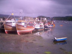
Day 17 May 27th Fionnphort
There is no track for today, as I didn't cycle anywhere. Once again the day started wet and windy. I walked into Fionnphort in time to meet the boat trip to Staffa. They had changed the schedule since there were not enough people going to warrant two trips. I had a couple of hours to kill before the trip, so I bought a hat and got some postcards for family members without internet access. I felt just like a proper tourist!
As time went on, the day brightened and the delay in the trip turned out to be for the best. The trip to Staffa takes about 40 minutes and involves crossing open waters where Atlantic rollers stream in. It was fine going out where we were running with the swell, but really wet and wild coming back!
Staffa itself is amazing. Hexagonal bassalt columns are everywhere, Fingals cave, inspiration for Mendelsohn's Hebrides overture, is massive and the Atlantic swells crash into it. The approach to the cave is along the side of the island walking on the bassalt columns with only a wire handrail for guidance.
Climbing onto the top of Staffa it's possible to walk along the island getting views of cliffs, sea and other islands beyond. The hour ashore was just enough. The trip back was very wet for those of us outside. I decided to stop off on Iona on the way back to get a cup of tea and to dry out.
Then it was onto the ferry back to Mull for the last time.
As this was my last day in Fionnphort, I decided to have dinner. I was about to walk across to the village from the B&B when out of nowhere came a violent squall with gale force winds and hale. It lasted 10 minutes or so. After it had gone through the rest of the evening was calm and bright. A curry, washed down with a couple of pints was a fitting way to end this segment of the ride.
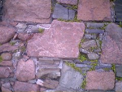
Today's picture is the wall of the ruined Nunnery on Iona where flowers and other plants are gradually taking over.
As time went on, the day brightened and the delay in the trip turned out to be for the best. The trip to Staffa takes about 40 minutes and involves crossing open waters where Atlantic rollers stream in. It was fine going out where we were running with the swell, but really wet and wild coming back!
Staffa itself is amazing. Hexagonal bassalt columns are everywhere, Fingals cave, inspiration for Mendelsohn's Hebrides overture, is massive and the Atlantic swells crash into it. The approach to the cave is along the side of the island walking on the bassalt columns with only a wire handrail for guidance.
Climbing onto the top of Staffa it's possible to walk along the island getting views of cliffs, sea and other islands beyond. The hour ashore was just enough. The trip back was very wet for those of us outside. I decided to stop off on Iona on the way back to get a cup of tea and to dry out.
Then it was onto the ferry back to Mull for the last time.
As this was my last day in Fionnphort, I decided to have dinner. I was about to walk across to the village from the B&B when out of nowhere came a violent squall with gale force winds and hale. It lasted 10 minutes or so. After it had gone through the rest of the evening was calm and bright. A curry, washed down with a couple of pints was a fitting way to end this segment of the ride.
Today's picture is the wall of the ruined Nunnery on Iona where flowers and other plants are gradually taking over.
Day 16 May 26 Fionnphort
Today's Track
Today dawned with torrential rain and gale force winds blowing from the west. Since I had the spare parts needed to fix the gradually failing gear change on my bike, I arranged with my hosts to spend the morning doing repairs I replaced the gear change/break control units, and checked and adjusted everything I could think of. This took most of the morning. Then, miraculously, as I was having a cup of tea having finished the maintenance work, the wind dropped, the rain stopped and the weather brightened. I headded out to test my fixes and to catch the ferry to Iona. I spent the afternoon cycling around Iona, sightseeing and taking photos.
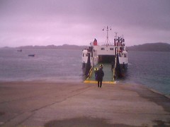
Today's photo actually shows the last passenger getting onto the ferry back to Mull. Today's track looks a little strange since it includes the ferry crossing to Mull and a long time spent in Fionnphort's only pub. As I arrived there, I met up with Luc, a Belgian cyclist on a tour of Scotland. I'd actually passed him a couple of days earlier when on my way to Oban. Luc is spending 4 weeks cycling around Scotland and in the process is raising money for a little girl with a brain tumor. More power to him. He's also camping as he tours, making my use of B&B's look like a really soft option! We spent a very pleasurable couple of hours in the pub shooting the breeze and putting the world to rights. It was a priviledge to buy him a beer.
Actually our paths may well cross again. He is also touring on Skye, though he will get there a day or two before me. Good luck luc!
Today dawned with torrential rain and gale force winds blowing from the west. Since I had the spare parts needed to fix the gradually failing gear change on my bike, I arranged with my hosts to spend the morning doing repairs I replaced the gear change/break control units, and checked and adjusted everything I could think of. This took most of the morning. Then, miraculously, as I was having a cup of tea having finished the maintenance work, the wind dropped, the rain stopped and the weather brightened. I headded out to test my fixes and to catch the ferry to Iona. I spent the afternoon cycling around Iona, sightseeing and taking photos.
Today's photo actually shows the last passenger getting onto the ferry back to Mull. Today's track looks a little strange since it includes the ferry crossing to Mull and a long time spent in Fionnphort's only pub. As I arrived there, I met up with Luc, a Belgian cyclist on a tour of Scotland. I'd actually passed him a couple of days earlier when on my way to Oban. Luc is spending 4 weeks cycling around Scotland and in the process is raising money for a little girl with a brain tumor. More power to him. He's also camping as he tours, making my use of B&B's look like a really soft option! We spent a very pleasurable couple of hours in the pub shooting the breeze and putting the world to rights. It was a priviledge to buy him a beer.
Actually our paths may well cross again. He is also touring on Skye, though he will get there a day or two before me. Good luck luc!
Day 15 May 25th Fionnphort
Today's Track
After the rigours of the last couple of days, today's ride was considerably easier and the weather a lot better.
The ferry crossing from Oban was smooth with some good opportunities for photography. Once on Mull, the limited mileage for today meant that I could take my time and stop fpr photos.
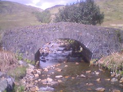
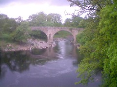
Today's picture is of a stone bridge that carried the old road to Fionnphort.
Oddly enough, progress on Mull was limited by the continuing headwinds but also by the traffic. Most of Mull's roads are single track with passing places. They are so narrow that it is actually difficult to get even a bike past a car. Consequently I had to keep stopping to let traffic past.
The walk from the B&B to the town of Fipnnphort is takes about 15 minutes. I tested this by visiting the local pub. For the first time in Scotland, I've found a decent pint, in this case of McEwan's 80 shilling.
After the rigours of the last couple of days, today's ride was considerably easier and the weather a lot better.
The ferry crossing from Oban was smooth with some good opportunities for photography. Once on Mull, the limited mileage for today meant that I could take my time and stop fpr photos.
Today's picture is of a stone bridge that carried the old road to Fionnphort.
Oddly enough, progress on Mull was limited by the continuing headwinds but also by the traffic. Most of Mull's roads are single track with passing places. They are so narrow that it is actually difficult to get even a bike past a car. Consequently I had to keep stopping to let traffic past.
The walk from the B&B to the town of Fipnnphort is takes about 15 minutes. I tested this by visiting the local pub. For the first time in Scotland, I've found a decent pint, in this case of McEwan's 80 shilling.
Wednesday, May 24, 2006
Day 14 May 24th Oban
Today's Track You'll see that I had a small problem with equipment today and the first few miles of track were not recorded.
Today's picture is a view over Achnacree bay not far from Oban during one of the few bright spells.
Today actually turned out to be the nighmare I'd been fearing for a few days. The weather forecast was spot on again. Torrential rain, strong headwinds and more hail made this a ride of almost unrelenting misery. For quite a time today, I was not really sure whether I'd be able to make it all the way to Oban or not. Progress was very slow once I turned into the very strong winds. The terrain was never difficult, and in more favourable conditions, with the magnificent scenary of the glens, this could have been a stunning day. As it was the high point was finding the guest house in Oban.
May 23rd Day 13 Brig o'Turk
Today's Track
After a day off, I was a little worried about today's ride. With 71 miles to do and predictions of wet weather and head winds, I decided to set off early. As it turned out, most of the day was dry and bright. The south westerly winds were brisk and affected my speed, but the terrain was pretty easy again. After working around the west side of Edinburgh, crossing the Forth road bridge was a delight. Unfortunately, the cycleway nearest the rail bridge was closed, so photographic options were a bit limited. Today's picture is the rail bridge taken from the Rosythe side.
Just before Stirling, I met a cyclist who is planning on doing John O'Groats to Land's End later in the year. He was out on a day's training ride. We swapped plans and experiences. He's planning on camping.
Progress was steady all day and the whole experience very pleasant until mid afternoon when the first showers and even stronger winds arrived. Leaving Callendar for the final few miles to Brig o'Turk, the heavens opened and there was a torrential downpour. I got soaked and arrived at the B&B dripping wet. My kit is now draped all over the Aga, gently steaming!
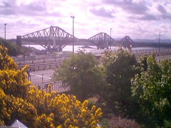
Monday, May 22, 2006
Day 12 May 22nd Still Edinburgh
Today was a rest day. No cycling, hence no track. Instead, I attended the W4A2006 workshop at the Edinburgh International Conference Centre. The organisation for the event was a bit shambolic. I was not listed as an attendee even though I was giving a keynote presentation! It took the best part of an hour to get a badge. On the plus side that gave me ample time to get to a bicycle shop and buy some spare parts to try and fix the problems I still have with my gears. I'll fix them when I get to Mull and have another day off. The full extent of the organisational problems at the conference became apparent when they ran out of food at lunchtime with still 50 or so people unfed. Whoops!
Sunday, May 21, 2006
May 21st Day 11 Edinburgh
Today's Track
That's more like it! Dry weather and great scenary went together to make this one of the best day's rides yet.
Today's picture is a view over the Eskdalemuir forest.
After a truly enormous breakfast, I left Eskdalemuir and made good progress up the valley of the White Esk. Although the route climbs steadily the gradients are much easier than those in Devon and Cornwall and average speeds are much higher. I made Innerleithen by lunch time. From their, the route followed the B709 over the hills to Edinburgh. Once again there are significant climbs but at easier gradients. Leaving Innerleithen, the route passes through the local golf course. It is squeezed in to the available space in between steep valley sides. A number of golfers were engaged in mountaineering expeditions to retrieve wayward drives and were playing some very unconventional lies!
After descending on the Edinburgh side of the hills I took a few minutes breather. While stopped in a bus stop, Angela arrived behind me. She had been following the same route on her way up from Winchester and finally caught me up 10 miles of so from our destination.
We went out for dinner, my first since Bristol a week ago. I had my first beer since the night before starting in Land's End.
Saturday, May 20, 2006
May 10th Day 10 Scotland at Last!
Today's Track
Although the rain started as I left Lazonby, it soon turned showery and eventually stopped. Today's picture is of Newbiggin Fell, repleat with dry stone walls.
The route today passed through a few small villages. The terrain was, for the most part, undulating.
I crossed into Scotland on a minor road with no signs or other indication. Where I crossed it, the border actually runs down the middle of Liddel Water, a tributary of the Esk.
In Langholm, I met a group of cyclists out on a day tour from Dumfries. We talked of routes and experiences.
The major climb of the day was the section from Langholm to Eskdalemuir through the Eskdalemuir forest.
Friday, May 19, 2006
May 19th Day 9 Lazonby
Today's Track
If I had to pick a word to describe today's ride it would have to be 'dreary'. Yet again, rain was the main feature of the day. Cloud was also very low and firmly anchored to the tops of the fells.
Today's picture is the old bridge over the river Lune at Kirkby Lonsdale. I managed to take this before the rain set in.
The planned route for today included a climb up Garsdale to an altitude of about 1000 feet. I made the decision to take the alternative short cut when I got to Sedbergh. I also managed to get a support for my knee. It is still sore when I walk on it but not when I'm cycling.
The direct route to Kirkby Stephen was a lot more gentle than Garsdale would have been and shortened the route considerably. The last section from Appleby-In-Westmoreland recalled a family holiday in the area from a few years ago when we rented a cottage in the heartland of the foot and mouth crisis
Thursday, May 18, 2006
May 18th Day 8 Kirkby Lonsdale
 May 18th day 8 Kirkby Lonsdale
Originally uploaded by rhesus42.
May 18th day 8 Kirkby Lonsdale
Originally uploaded by rhesus42. Wednesday, May 17, 2006
May 17th Day 7
Track for Day 7
Today was probably the least pleasant so far. Actually it started pretty well, arriving in Ironbridge from Broseley over the bridge itself. By the way, today's picture really couldn't have been of anything other than this astonishing and visionary piece of civil engineering.
The real problems began after lunch. The promised band of rain started to arrive from the south, gradually getting harder and harder throughout the afternoon. But even that was not the worst part. That honour goes to having to cycle over 35 miles on the A49, a fast main road carrying a lot of traffic. And at the end of the day, I had to negotiate rush hour in Warrington in the pouring rain.
The most exciting moment of the day was changing down to negotiate an uphill double bend on the A 49 only to have the chain come off while I was right in front of a 44 ton articulated lorry. Let's hope tomorrow is better.
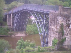
Tuesday, May 16, 2006
How small is my country?
I've been thinking, over the last couple of days, about just how small England is. After all, even at my rather leisurely pace, I'll be traversing the entire country in just over a week. Today, I crossed the entire county of Worcestershire in a matter of a few hours. For me, as a cynical, grumpy old fifty-something, it makes the airs and graces assumed by our hapless senior politicians even more absurd. Here near Ironbridge and the cradle of the Industrial Revolution it seems appropriate to be reminded of just what effect the technologies created in the United Kingdom have had upon the world. Things move on, of course, The raw materials for success in today's world are owned by other nations. We seem destined to play a smaller and smaller global role in the future. Frankly, given some of the foreign policy decisions of our politicians over the last few years, that should be viewed as good news for everyone.
Day 6 Track
Track for Day 6
I forgot to inckude the link to today's track in my last post. Posting again does give me the chance to include a rather ropey picture of Worcester Cathedral from the main bridge over the river.
I forgot to inckude the link to today's track in my last post. Posting again does give me the chance to include a rather ropey picture of Worcester Cathedral from the main bridge over the river.
May 16 Day 6 Broseley
The terrain north of Bishop's Cleeve continues to be very flat, so progress was brisk early in the ride. Today's picture is a narrow boat on the Avon about to pass under Eckington bridge. Pershore came and went and I was soon in Worcester. Gear changing had become increasingly difficult, so I spent a few minutes trying to find a bike shop to get some spray lubricant. I failed, so headed on towards Stourport. A couple of miles outside Worcester, the reason for the trouble became immediately aooarent when the rear gear cable broke. I was left with drive , which was a blessing, but a very low ratio. I headed back towards Worcester and as luck would have it, passed a bloke holding a bike and chatting to a friend. Mick, for that was his name, was able to direct me to Peddlers bike shop where Rob was magic in helping replace the failed cable. I bought a spare and some additional tools in case I need to do a subsequent repair on the side of the road.
After that adventure, the rest of the ride to Broseley, just outside Ironbridge, was relatively straightforward. I managed to miss a photo opportunity with the Severn Valley railway, a restored, steam operated line. I was about half a mile short of a perfect vantage point when the last train of the day went by.
Broseley's claim to fame, by the way, was the manufacture of clay pipes. My mother assures me that a great aunt of hers was famed for smoking one!
May 15th Day 5 Bishop's Cleeve
Today's TrackAfter a great evening at my Mum's, I woke up with a worse cold and a very sore left knee. The good news was that today's ride was quite short at just under 50 miles. There was rain first thing in Bristol and it stayed around all day. My sister turned up in the morning so I did not get away as early as I'd planned. Also, around lunchtime, I got a call from my brother that resulted in a natter in a pub just outside Dursley. My knee turned out not to be a problem and the ride itself was much easier than Cornwall or Devon. I arrived in Cheltenham just as the sun made a brief appearance.
Todays picture is a typical Cotswold stone house in the Slad valley.

Todays picture is a typical Cotswold stone house in the Slad valley.
Sunday, May 14, 2006
May 14th Day 4: Bristol
There is no track today. Although the GPS worked faultlessly all day, when I came to stop recording, my Axim seemed to have turned itself off :(
For the first time this trip, the day started with an easy cruise across the Somerset Levels from Bridgwater. For the first hour or so, the going was very easy, until the climb up to Wokey Hole before the descent into Wells. The centre of Wells had been taken over by a film crew shooting a new comedy called 'Hot Fuzz'. At least, that's what the marshall keeping people away from key parts of the shoot told me.
Today's picture is of Wells Cathedral, by the way.
From Wells to Bath, there were a number of steep climbs. As I seem to have caught a cold, I decided to alter the route into Bristol and shorten it by a few miles. This got me to my Mum's in time for a hot bath and a great dinner!
Saturday, May 13, 2006
May 12th Day 2 Dartmoor
Today's track is at http://maps.jonesey.net/GPXtrack.html?gpx=e2e20060512gpx. I discovered two things today. First, eveyone is right about how hard the climb over Dartmoor is. Second, there is virtually no mobile phone signal in Moretonhampstead, my overnight stop. Hence the delay in posting this entry Also, no picture today as I've had trouble uploading to flickr. Riding today was every bit as hard as yesterday. I'd managed to pick a route with some very steep climbs even before getting to Tavistockand the start of the Dartmoor section. The climb up onto the moor is steep and unrelenting. Once past Princetown, with the enormous North Hesary Tor transmitter and the brooding Dartmoor prison, things were a little easier. There were a few light rain showers during the day, and there was thunder in the distance, but thankfully not where I was.
May 13th Day 3: Bridgewater
Today's Track
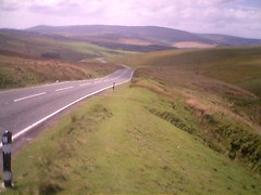
Today's route didn't really go past anything particularly significant There were lots more hills to climb. Today's picture is an attempt to show a steep lane with Devon countryside in the background. Really it just illustrates how hard it is to take good landscapes with the wide angle lens on a typical mobile phone.
Once again, the route I'd picked was very slow because of the number of big climbs. The sting in the tail was having to get over the Quantock hills before sweeping down to Bridgwater.
It was overcast for most of the day, but mercifully, the wind was from a favourable direction.
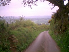
Thursday, May 11, 2006
Track for Day 1
Once the track for day 1 has been converted, you should be able to view it
href="http://maps.jonesey.net/GPXtrack.html?gpx=e2e20060511.gpx">here.
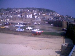
The picture in this post is harbour at Mousehole. Some of my relatives on my mother's side of the family were fishermen based here some 150 years ago.
href="http://maps.jonesey.net/GPXtrack.html?gpx=e2e20060511.gpx">here.
The picture in this post is harbour at Mousehole. Some of my relatives on my mother's side of the family were fishermen based here some 150 years ago.
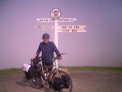
May 11th: Day 1
Thursday dawned foggy at Land's End. Thick blowing mist, remeniscent of San Francisco persisted for much of the morning. We had the obligatory enourmous full English breakfast, then headed for the startf. Despite the negative effect of the fog on photographs, I posed for the mandatory shots in front of the famous sign post. Then it was off and pedalling. As it turned out, this was one of the hardest days cycling I've ever done. A late start, some teetinng troubles with the bike and some really steep hills conspired to make my average speed rather low. I didn't even make it to the Ferry at Falmouth until after 4pm and finally rolled into Par at around 8pm.
I've been amazed and touched at people's generosity today. Complete strangers have been approaching me and donating money to the charities.
As you'll see from my track, once again I forgot to start the GPS running until a mile or so into the ride. Doh!
I've been amazed and touched at people's generosity today. Complete strangers have been approaching me and donating money to the charities.
As you'll see from my track, once again I forgot to start the GPS running until a mile or so into the ride. Doh!
Wednesday, May 10, 2006
Getting to Land's End
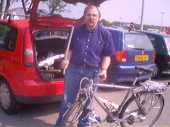
I'd like to be able to say that the journey to Land's End was completely without incident. Unfortunately, a sharp encounter with a car park height barrier in Exeter spoiled what until then had been a really smooth and easy journey. Traffic had been really light and the weather was improving. We stopped for lunch at Exeter services. As Angela wanted to visit Exeter Cathedral on her way back to Winchester, I suggested that we check out the park and ride facility nearby. I turned into the car park and under the barrier without thinking about the bike on the roof. There was a loud bang, and when we stopped, the bike, roof rack carrier and all were in the road behind us! The bike got off pretty lightly, which is more than can be said for the car Anyway, to cut a long story short, an hour in the car park outside Halfords in Penzance, and the bike seems ready to go.
Land's End was shrouded in mist when we arrived, so not much chance for photography tonight. We're off to the pub instead!
Land's End was shrouded in mist when we arrived, so not much chance for photography tonight. We're off to the pub instead!
Tuesday, May 09, 2006
Making Tracks
Martin Jones, aka Jonesey, a colleague at Volantis, has now become unofficial 'mission control' for the ride. Martin has set up a web page on his server through which you'll be able to see my progress each day. For example, you can see the track of my ride around the Isle of Wight at Randonnee track.
Each evening, I'll be sending Martin a file of the day's ride from my GPS unit. Martin will convert it and upload it to his server. I'll include a link to the track from my daily blog entry. That's the plan anyway. As usual it will depend on mobile coverage in the area in which I'm staying overnight.
Many thanks go to Martin for setting this up and for agreeing to do the conversions.
Sunday, May 07, 2006
Final Preparations
I've spent the weekend making the final preparations. Mainly this has involved printing additional information so that I have it with me on the ride. It's also involved a lot of packing. I took the bike out for a fully laden shake down today. It's carrying a few kilos more than on last week's Randonnee. I just did 16 miles or so to make sure everything was holding together. The new cable I fitted last week had stretched a little, so I needed to do some adjustments while I was out. Also, my pedals had worked slightly loose again and I could feel and hear movement. As a result, I've decided to take the right spanner with me in case that happens again en route.
I've also finally got round to joining the Cyclists Touring Club or CTC. I have to admit that my main motive is not the 3rd party insurance, the local events, or the Land's End to John O'Groats pack, but the lure of being able to buy T shirts and other trinkets once I've finished the end to end ride!
Friday, May 05, 2006
Fame at Last!
Through contacts at the RNIB, an article about the end to end ride appeared in the Southern Daily Echo on Thursday May 4th. I would post a link to the on-line version of the article here, but until it gets into the monthly archives, there is no fixed URL for it.
The photographer turned up last Tuesday with a Canon EOS 1Ds. This is the one with the full frame, 16 megapixel sensor. Apparently he uses an EOS 20 as his backup camera!
Monday, May 01, 2006
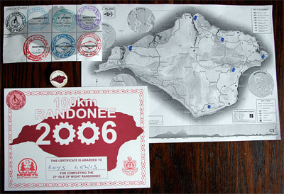
The Isle of Wight Randonnee 2006
My Randonnee track can be viewed on Google Maps (once I'd remembered to turn the GPS on! Many thanks to Martin Jones for setting this up.
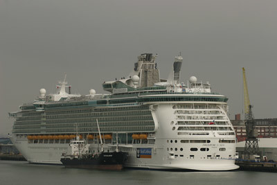
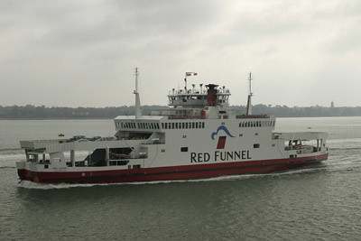
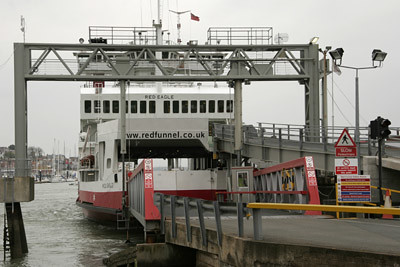
Sunday April 30th dawned grey but dry. The drive to Southampton was easy, as it should be at 7:30 on a Sunday. Several events happening in Southampton meant that parking would be a problem later in the day, but not at the time we arrived. The process of unloading the bike and attaching all the bits was going smoothly when all of a sudden, something akin to the voice of doom boomed out across the docks. It came from the "Freedom of the Seas", the world's largest cruise ship, moored close to the ferry terminal. She is visiting Southampton for a few days. The announcement was completely unintelligable, but very loud. I said goodbye to Angela, and headed for the ferry terminal. There were no queues for tickets, so there was time for coffee and a chat with fellow riders. None of the people I met seemed to have done the ride before. However, a few knew it by reputation and there were dire warnings, absolutely accurate as it turns out, about the hills. The crossing was entirely smooth, and there was a chance to photograph the source of the voice of doom as we left.
The ferries themselves have a very characteristic, symmetric design which means they do not need to turn around. They have three car decks, but only two were in operation. Bikes are allowed on first and off first, but there is no special storage. It was just as well that the crossing was smooth, or there might have been a pile of very expensive machinery all over the deck.
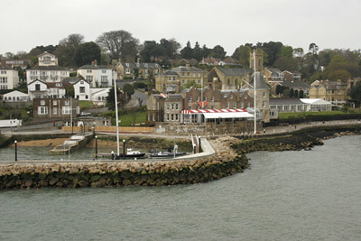
The threatened showers never materialized, but the entire day was overcast and rather grey. Even so, the entrance to Cowes harbour on the west side still manages to be picturesque.
After leaving the ferry, finding the first checkpoint was easy. It took a few minutes to sign on and to get a route card. Riders have to collect stamps at each checkpoint. If you collect the full set, you receive a certificate and can purchase a badge commemorating the event. More on this later. At this point there was the small matter of 67 miles of cycling before that could happen. At this point, the dearth of further photos shows that I was very focused on the ride ahead. Actually I was so focused that I forgot to turn on my GPS , so for the first 7 miles I didn't collect any track data. Doh! Mental note to self to pay more attention to this on the end to end ride.
Riders get a pretty good indication of what is to come with the first climb out of Cowes. It's fairly steep, but what marks it out is the way it goes on and on. This is a feature of many of the climbs on the island. I made my first, and as it turned out, only map reading error within a couple of miles of the start. The exuberance of conquering the first hill and of passing a number of people on the way up led to me missing a turn and putting in a couple of extra miles and one additional climb. Luckily for me, when I rejoined the main route, I was behind some riders who knew where they were going so finding the checkpoint in Wooton was easy. One down, five to go. And I remembered to turn on the GPS. After Wooton, the route settles down into a series of sharp climbs and equally sharp descents which was to set the tone for most of the rest of the ride. The combination of bicycles and horses out and about were certainly causing some interesting traffic challenges for locals and tourists alike.
Shortly before Bembridge, the GPS proved its value for the first time. I'd met up with a couple of other riders and we were travelling in a rough convoy. We reached a road junction and after a few minutes adjusting brakes on one of the bikes, had to decide where we were and which way to go. Out with the Axim for a quick look at our track and with uncertainty dismissed we were off. The route around Bembridge harbour is flat and provides a welcome respite from hill climbing, albeit temporarily. Finding the Bembridge checkpoint was tricky, with the school location well hidden, and one sign missing. Helpfully, a stream of riders emerging from a side road provided the hint, and we found it with only a small overshoot. Two down, four to go.
Leaving Bembridge by a road that passes the airport, the GPS came into its own again. While making yet another ascent, another rider came alongside and asked if I'd found the checkpoint in Bembridge. We pulled over and out came the Axim again so I could show him exactly where it was. GPS 2, Getting Lost 0. After this pause in proceedings, I'd lost touch with the others so carried on alone on the relatively short stage to Alverstone. Again this involved much climbing and descending, with many of the ascents steep and long. My average speed while on the move was down to a worrying 11.3 mph by this stage. I started to be concerned that I might not make it back to Cowes before the final checkpoint closed. At Alverstone there was a chance to replenish water supplies on the bike, to go to the loo and, of course pick up the next stamp. Three down three to go.
I'd finally settled into a rhythm by this stage. The map reading was going fine and I felt in control. A bit of mental arithmetic showed that I ought to make it back to East Cowes between 5:30 and 6pm, in time for the all important final stamp and in time to catch the 6:30pm ferry. There were two memorable moments on the section between Alverstone and the next check point at Whitwell. First, was the chaos that cyclists were causing in Wroxall. The route rejoins the main road for a short climb through the middle of the town. The bicycles together wih cars parked down one side of the street had the whole place at a virtual standstill. The second moment was sweeping down into Ventnor off Wroxall Down, with a clear view of the channel to the south, while letting gravity do the work for a change.
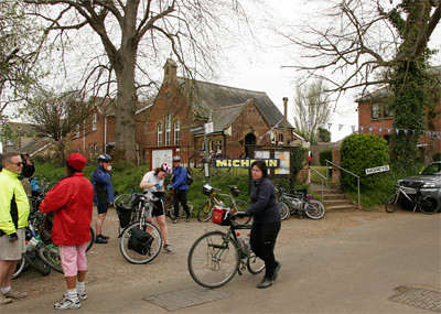
The checkpoint at the church hall in Whitwell was selling chocolate bars. As it was nearly lunch time, I bought a couple, one for then, one for later. Stamp number four was duly claimed. Four down, two to go. I did at least remember to take a picture at this checkpoint. However, it completely fails to capture how busy it was with riders resting, getting checked in, arriving and leaving.
At Whitwell, the route divides. The shorter, 30 mile route heads directly back to East Cowes. But for the true masochist, the longer route strikes west. At Niton, it rejoins the main road that runs along the south coast of the island and shortly after, there is one more chance to let gravity take over and zoom back down close to sea level. After a couple of miles of main road, the route strikes inland through a series of villages. Once again, climbs follow in succession, but generally things are less brutal here than to the east of the island. A little after passing the mill at Yafford, it was time to devour a second chocolate bar. Fortunately, soon afterwards, supplies were replenished from a store in Brighstone. Shortly after, it was back onto the south coast main road and one of the most sever tests of the entire trip.
Around Compton bay, the main road has to ascend a substantial distance in two major climbs separated by a steep descent. Even though it passes through two cuttings and is straight, the gradient is steep and each climb seemingly unending. The wind was also against us. Some of the people who had passed me earlier on lightweight racing bikes were actually forced to get off and walk for portions of this climb. It was quite satisfying not to have to do that and to be able to pass them again on the way up! Once this challenging section was complete, things were much easier for the rest of the way into Yarmouth. The route takes to a track that runs alongside the Yar river and is virtually level. At this point we were also travelling down wind, so progress was rapid. Into the checkpoint at Yarmouth, and time for stamp number five. Five down, one to go. I celebrated by buying a cup of tea.
To be honest, the last section to Cowes was uneventful. Every turn to the south brought a strong headwind, and there were still hills to negotiate. But for the most part, the hardest work had already been done. Until I got to West Cowes, that is. The drop down to Gurnard is deceiving. The south coast of the mainland comes into clear view and you descend to sea level. The assumption that the route is now simply along the shore is soon dispelled with a steep climb. Descents and climbs follow in succession, with some of the steepest on the whole journey being saved for the last couple of miles. Even after the trip around Cowes Esplanade past Egypt Point, there are still a couple of brutish hills to negotiate before the final drop down to the floating bridge. At this point, the fact that I could see the ferry I was about to miss, still moored at the terminal, mattered not a jot. After the free trip on the floating bridge across the Medina which, by the way, was in full and frighteningly strong ebb, it was less than 100 metres back to the Cowes checkpoint. I collected the final stamp, my certificate and a badge.
Then it was just a question of waiting a few minutes for the 6:30pm ferry to arrive. It was definitely a welcome site for the tired cyclists assembled in the car park. Well, actually, most were in the pub opposite.
So that's it. The last major training outing, before the end to end ride starts in just over a week, is over. The equipment worked well, once I remembered to switch it on! The bike performed well, though I'll change the brake blocks and a gear cable before setting off and I'll clean and adjust everything one more time. I'm about as ready as I can be.
Subscribe to:
Posts (Atom)