I've now processed the photos that I took along the way. This time they are pictures from my camera, rather than from my mobile phone, so they are a lot bigger!
The pictures are available at my Flickr site in a set called LE-JOG 2006.
I've now processed the photos that I took along the way. This time they are pictures from my camera, rather than from my mobile phone, so they are a lot bigger!
The pictures are available at my Flickr site in a set called LE-JOG 2006.
Susan & Frank Trzebiatowski, Burnt Inn House, Brig O'Turk, Callander, FK17 8HT, 01877 376212
Valerie Bichener, Thornloe, Albert Road, Oban, PA34 5JD, 01631 562879
Heather Heald, Bruachnhor, Fionnphort, Isle of Mull, PA66 6BL, 01681 700276
Heather McLauchlan, Castle Croft, Beaudoun, Tobermory, Isle of Mull, PA75 6QA, 01688 302388
Mrs Isa Mary McDonald, Ardnish, 15 Blaven View, Mallaig, PH41 4QR, 01687 462111
Rachael Thornton, Green Gables House, Harrapool, Broadford, Isle of Skye, IV49 9AQ, 01471 820211
Mr & Mrs T Pritchard, Java Croft, 13 Earlish, Uig, Isle of Skye, IV51 9XL, 01470 542361
Judith Fish, The Applecross Inn, Applecross, Wester Ross, IV54 8LR, 01520 744262
David & Lilah Ford, Hillhaven, Kinlochewe, Achnasheen, Ross-Shire, IV22 2PA, 01445 760204
Mrs A. Ross, 4 Camusnagaul, Dundonnell, By Garve, Ross-Shire, IV23 2QT, 01854 633237
Alan & Fiona Donaldson, Old School Restaurant & Rooms, Inshegra, By Kinlochbervie, IV 4RH, 01971 521383 & 07789 743234
Jenny & Stuart Anderson, Rhian Guest House, Tongue, Sutherland, IV27 4XJ, 01847 611257 & 0771 9668149
Alistair Grant, John O'Groats Guest House, The Broo, Caithness, John O'Groats, KW1 4YR, 01955 611251
I promised to list the details of where I stayed on each overnight stop. Without hesitation, I'd stay in any one of these again. Everyone I stayed with was welcoming and very friendly. Here is the first part of the list.
Liz Trenary,Treeve Moor House, Sennen, Penzance, TR19 7AE, 01736 871284
Mrs V Symons, Treyarnon House,19 South Park Road, Tywardreat, Par, PL24 2PU, 01726 815326
Mrs T Williams, Cookshayes Country Guesthouse, Court Street, Moretonhampstead, TQ13 8LG, 01647 440374
Mrs Susan Parker, The Admirals Rest, 5 Taunton Road, Bridgewater, TA6 3LW, 01278 458580
In Bristol I stayed with my mum, so I dont have a B&B to list.
Mrs Joy Merrell, Barn End, 23 Cheltenham Road, Bishop's Cleeve, Cheltenham GL52 8LU, 01242 672404
Ros Havard & Paul Mortimer, Broseley House, 1 The Square, Broseley, Shropshire TF12 5EW, 01952 882043
Mary McDonough, 99 Hob Hey Lane, Culcheth, Warrington, WA3 4NS, 01925 763448
Mrs Pat Bradley, Wyck House, 4 Main Street, Kirkby Lonsdale, Cumbria LA6 2AE, 015242 71953
Mrs Carlyle, Bank Top House, Lazonby, Penrith, CA10 1AQ, 01768 898268
John & Kath Leadbeater, Hart Manor, Eskdalemuir, Langholme, Dumfriesshire, DG13 0QQ, 013873 73217
Carolyn & Les Davidson, Aaron Glen Guesthouse, 7 Nivensknowe Road, Loanhead, Midlothian, EH20 9AU, 0131 4401293
During the last couple of days of the ride, I had started to think about how I was going to describe it. What would I say when people asked me how it had been? How could I sum it up?
In any activity lasting a month, there are bound to be highs and lows. Making it over Bealach na Ba on the way to Applecross was a definite high, especially as the weather cooperated for once. In fact, the whole section in north west Scotland and on Skye and Mull was superb. I'll definitely be visiting that area again in the future. On the other hand, the rides to Oban and to Mallaig were really tough, mainly because of the weather. The final day to John O'Groats was also very disappointing, with fog preventing views of Orkney.
On the plus side, the only mechanical failure I had on the bike was minor and I avoided punctures completely. Having said that, I did know that my rear wheel was out of true by the end. I've just found out how bent one of the spokes is. I was lucky not to have had a breakage. Actually, the only real threat to the entire schedule was the Skye ferry breaking down. I was really lucky not to have to go far that particular day.
The electronic technology held up pretty well too. I always knew where I was and had enough soft copy maps on my PDA to be able to reroute where necessary. I always had enough battery power for an entire day's ride and was always able to recharge over night.
My only real health worry was my left knee, but once I'd taken to using a support when off the bike, it just got better and better. Saddle sores were a constant annoyance, despite liberal use of Johnson's baby lotion. Last time I'd used that was on my children, while changing their nappies! By the way, cattle grids and bad road surfaces can be really painful!
Overall, I'd say that this was more of a challenge than I expected, but that most of that was due to the weather. I had not anticipated such strong winds, nor had I expected the run of bad luck in wind direction.
Am I glad I did it? Absolutely! Would I go on a cycling tour again? Yes, definitely, though I'd I'd probably not attempt such a long trip next time and I'd build a bit more slack into the schedule.
Along with memories of the ride itself, I have fond memories of the people I've met along the way. From the folks I've stayed with to the cyclists and walkers I've encountered and the people who've spontaneously donated to the charities I've been supporting, everyone has been fantastic. By the way, I've heard from Luc since I got home. He made it to the Hebrides. His ride finishes this week.
I'm not quite finished adding material here. I will post the list of places I stayed. I'll also be working on uploading at least some of the pictures I took with my camera, as opposed to my mobile phone. I'll post a link to them here too.
By the way, cycling is, as we all know, fantastic exercise. Over the time of the trip I managed to lose somewhere between 8 and 9 kilograms, weight that I definitely needed to lose. And that was despite a full cooked breakfast every day. The trouble is, none of my clothes fit any more!
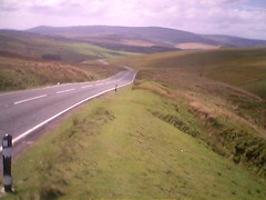
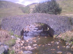
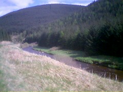
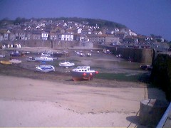
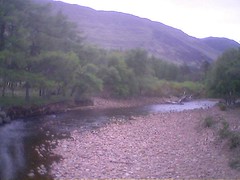 Day 25 June 4th Kinlochewe
Originally uploaded by rhesus42.
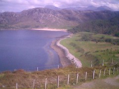
Day 25 June 4th Kinlochewe
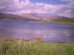
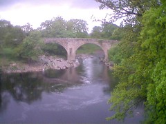
Originally uploaded by rhesus42. 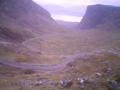 Day 24 June 3rd Applecross
Originally uploaded by rhesus42.
Day 24 June 3rd Applecross
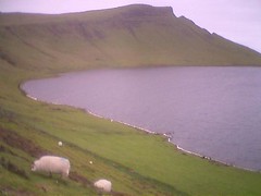
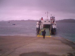
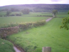
Originally uploaded by rhesus42. 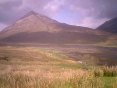 Day 23 June 2nd Broadford
Originally uploaded by rhesus42.
Day 23 June 2nd Broadford
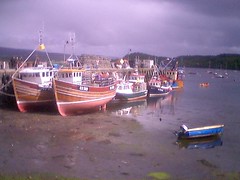
Originally uploaded by rhesus42. 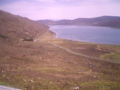 Day 21 May 31st Uig
Originally uploaded by rhesus42.
Day 21 May 31st Uig
Originally uploaded by rhesus42. Today was a rest day. No cycling, hence no track. Instead, I attended the W4A2006 workshop at the Edinburgh International Conference Centre. The organisation for the event was a bit shambolic. I was not listed as an attendee even though I was giving a keynote presentation! It took the best part of an hour to get a badge. On the plus side that gave me ample time to get to a bicycle shop and buy some spare parts to try and fix the problems I still have with my gears. I'll fix them when I get to Mull and have another day off. The full extent of the organisational problems at the conference became apparent when they ran out of food at lunchtime with still 50 or so people unfed. Whoops!
 May 18th day 8 Kirkby Lonsdale
Originally uploaded by rhesus42.
May 18th day 8 Kirkby Lonsdale
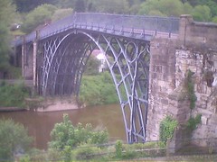
Originally uploaded by rhesus42. I've been thinking, over the last couple of days, about just how small England is. After all, even at my rather leisurely pace, I'll be traversing the entire country in just over a week. Today, I crossed the entire county of Worcestershire in a matter of a few hours. For me, as a cynical, grumpy old fifty-something, it makes the airs and graces assumed by our hapless senior politicians even more absurd. Here near Ironbridge and the cradle of the Industrial Revolution it seems appropriate to be reminded of just what effect the technologies created in the United Kingdom have had upon the world. Things move on, of course, The raw materials for success in today's world are owned by other nations. We seem destined to play a smaller and smaller global role in the future. Frankly, given some of the foreign policy decisions of our politicians over the last few years, that should be viewed as good news for everyone.
Today's track is at http://maps.jonesey.net/GPXtrack.html?gpx=e2e20060512gpx. I discovered two things today. First, eveyone is right about how hard the climb over Dartmoor is. Second, there is virtually no mobile phone signal in Moretonhampstead, my overnight stop. Hence the delay in posting this entry Also, no picture today as I've had trouble uploading to flickr. Riding today was every bit as hard as yesterday. I'd managed to pick a route with some very steep climbs even before getting to Tavistockand the start of the Dartmoor section. The climb up onto the moor is steep and unrelenting. Once past Princetown, with the enormous North Hesary Tor transmitter and the brooding Dartmoor prison, things were a little easier. There were a few light rain showers during the day, and there was thunder in the distance, but thankfully not where I was.
Martin Jones, aka Jonesey, a colleague at Volantis, has now become unofficial 'mission control' for the ride. Martin has set up a web page on his server through which you'll be able to see my progress each day. For example, you can see the track of my ride around the Isle of Wight at Randonnee track.
Each evening, I'll be sending Martin a file of the day's ride from my GPS unit. Martin will convert it and upload it to his server. I'll include a link to the track from my daily blog entry. That's the plan anyway. As usual it will depend on mobile coverage in the area in which I'm staying overnight.
Many thanks go to Martin for setting this up and for agreeing to do the conversions.
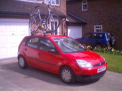
I've spent the weekend making the final preparations. Mainly this has involved printing additional information so that I have it with me on the ride. It's also involved a lot of packing. I took the bike out for a fully laden shake down today. It's carrying a few kilos more than on last week's Randonnee. I just did 16 miles or so to make sure everything was holding together. The new cable I fitted last week had stretched a little, so I needed to do some adjustments while I was out. Also, my pedals had worked slightly loose again and I could feel and hear movement. As a result, I've decided to take the right spanner with me in case that happens again en route.
I've also finally got round to joining the Cyclists Touring Club or CTC. I have to admit that my main motive is not the 3rd party insurance, the local events, or the Land's End to John O'Groats pack, but the lure of being able to buy T shirts and other trinkets once I've finished the end to end ride!
My Randonnee track can be viewed on Google Maps (once I'd remembered to turn the GPS on! Many thanks to Martin Jones for setting this up.
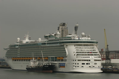
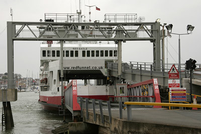
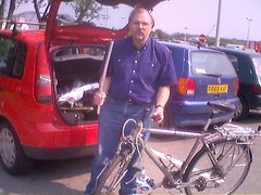
Sunday April 30th dawned grey but dry. The drive to Southampton was easy, as it should be at 7:30 on a Sunday. Several events happening in Southampton meant that parking would be a problem later in the day, but not at the time we arrived. The process of unloading the bike and attaching all the bits was going smoothly when all of a sudden, something akin to the voice of doom boomed out across the docks. It came from the "Freedom of the Seas", the world's largest cruise ship, moored close to the ferry terminal. She is visiting Southampton for a few days. The announcement was completely unintelligable, but very loud. I said goodbye to Angela, and headed for the ferry terminal. There were no queues for tickets, so there was time for coffee and a chat with fellow riders. None of the people I met seemed to have done the ride before. However, a few knew it by reputation and there were dire warnings, absolutely accurate as it turns out, about the hills. The crossing was entirely smooth, and there was a chance to photograph the source of the voice of doom as we left.
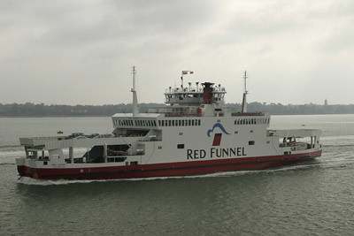
The ferries themselves have a very characteristic, symmetric design which means they do not need to turn around. They have three car decks, but only two were in operation. Bikes are allowed on first and off first, but there is no special storage. It was just as well that the crossing was smooth, or there might have been a pile of very expensive machinery all over the deck.
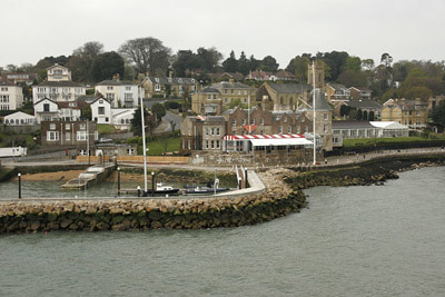
The threatened showers never materialized, but the entire day was overcast and rather grey. Even so, the entrance to Cowes harbour on the west side still manages to be picturesque.
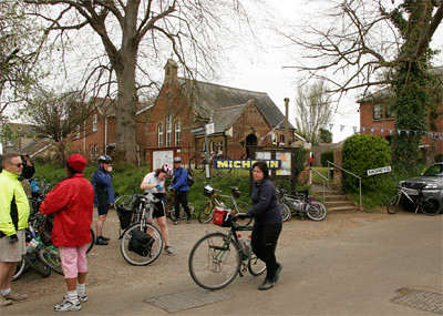
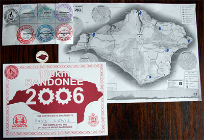
After leaving the ferry, finding the first checkpoint was easy. It took a few minutes to sign on and to get a route card. Riders have to collect stamps at each checkpoint. If you collect the full set, you receive a certificate and can purchase a badge commemorating the event. More on this later. At this point there was the small matter of 67 miles of cycling before that could happen. At this point, the dearth of further photos shows that I was very focused on the ride ahead. Actually I was so focused that I forgot to turn on my GPS , so for the first 7 miles I didn't collect any track data. Doh! Mental note to self to pay more attention to this on the end to end ride.
Riders get a pretty good indication of what is to come with the first climb out of Cowes. It's fairly steep, but what marks it out is the way it goes on and on. This is a feature of many of the climbs on the island. I made my first, and as it turned out, only map reading error within a couple of miles of the start. The exuberance of conquering the first hill and of passing a number of people on the way up led to me missing a turn and putting in a couple of extra miles and one additional climb. Luckily for me, when I rejoined the main route, I was behind some riders who knew where they were going so finding the checkpoint in Wooton was easy. One down, five to go. And I remembered to turn on the GPS. After Wooton, the route settles down into a series of sharp climbs and equally sharp descents which was to set the tone for most of the rest of the ride. The combination of bicycles and horses out and about were certainly causing some interesting traffic challenges for locals and tourists alike.
Shortly before Bembridge, the GPS proved its value for the first time. I'd met up with a couple of other riders and we were travelling in a rough convoy. We reached a road junction and after a few minutes adjusting brakes on one of the bikes, had to decide where we were and which way to go. Out with the Axim for a quick look at our track and with uncertainty dismissed we were off. The route around Bembridge harbour is flat and provides a welcome respite from hill climbing, albeit temporarily. Finding the Bembridge checkpoint was tricky, with the school location well hidden, and one sign missing. Helpfully, a stream of riders emerging from a side road provided the hint, and we found it with only a small overshoot. Two down, four to go.
Leaving Bembridge by a road that passes the airport, the GPS came into its own again. While making yet another ascent, another rider came alongside and asked if I'd found the checkpoint in Bembridge. We pulled over and out came the Axim again so I could show him exactly where it was. GPS 2, Getting Lost 0. After this pause in proceedings, I'd lost touch with the others so carried on alone on the relatively short stage to Alverstone. Again this involved much climbing and descending, with many of the ascents steep and long. My average speed while on the move was down to a worrying 11.3 mph by this stage. I started to be concerned that I might not make it back to Cowes before the final checkpoint closed. At Alverstone there was a chance to replenish water supplies on the bike, to go to the loo and, of course pick up the next stamp. Three down three to go.
I'd finally settled into a rhythm by this stage. The map reading was going fine and I felt in control. A bit of mental arithmetic showed that I ought to make it back to East Cowes between 5:30 and 6pm, in time for the all important final stamp and in time to catch the 6:30pm ferry. There were two memorable moments on the section between Alverstone and the next check point at Whitwell. First, was the chaos that cyclists were causing in Wroxall. The route rejoins the main road for a short climb through the middle of the town. The bicycles together wih cars parked down one side of the street had the whole place at a virtual standstill. The second moment was sweeping down into Ventnor off Wroxall Down, with a clear view of the channel to the south, while letting gravity do the work for a change.
The checkpoint at the church hall in Whitwell was selling chocolate bars. As it was nearly lunch time, I bought a couple, one for then, one for later. Stamp number four was duly claimed. Four down, two to go. I did at least remember to take a picture at this checkpoint. However, it completely fails to capture how busy it was with riders resting, getting checked in, arriving and leaving.
At Whitwell, the route divides. The shorter, 30 mile route heads directly back to East Cowes. But for the true masochist, the longer route strikes west. At Niton, it rejoins the main road that runs along the south coast of the island and shortly after, there is one more chance to let gravity take over and zoom back down close to sea level. After a couple of miles of main road, the route strikes inland through a series of villages. Once again, climbs follow in succession, but generally things are less brutal here than to the east of the island. A little after passing the mill at Yafford, it was time to devour a second chocolate bar. Fortunately, soon afterwards, supplies were replenished from a store in Brighstone. Shortly after, it was back onto the south coast main road and one of the most sever tests of the entire trip.
Around Compton bay, the main road has to ascend a substantial distance in two major climbs separated by a steep descent. Even though it passes through two cuttings and is straight, the gradient is steep and each climb seemingly unending. The wind was also against us. Some of the people who had passed me earlier on lightweight racing bikes were actually forced to get off and walk for portions of this climb. It was quite satisfying not to have to do that and to be able to pass them again on the way up! Once this challenging section was complete, things were much easier for the rest of the way into Yarmouth. The route takes to a track that runs alongside the Yar river and is virtually level. At this point we were also travelling down wind, so progress was rapid. Into the checkpoint at Yarmouth, and time for stamp number five. Five down, one to go. I celebrated by buying a cup of tea.
To be honest, the last section to Cowes was uneventful. Every turn to the south brought a strong headwind, and there were still hills to negotiate. But for the most part, the hardest work had already been done. Until I got to West Cowes, that is. The drop down to Gurnard is deceiving. The south coast of the mainland comes into clear view and you descend to sea level. The assumption that the route is now simply along the shore is soon dispelled with a steep climb. Descents and climbs follow in succession, with some of the steepest on the whole journey being saved for the last couple of miles. Even after the trip around Cowes Esplanade past Egypt Point, there are still a couple of brutish hills to negotiate before the final drop down to the floating bridge. At this point, the fact that I could see the ferry I was about to miss, still moored at the terminal, mattered not a jot. After the free trip on the floating bridge across the Medina which, by the way, was in full and frighteningly strong ebb, it was less than 100 metres back to the Cowes checkpoint. I collected the final stamp, my certificate and a badge.
Then it was just a question of waiting a few minutes for the 6:30pm ferry to arrive. It was definitely a welcome site for the tired cyclists assembled in the car park. Well, actually, most were in the pub opposite.
So that's it. The last major training outing, before the end to end ride starts in just over a week, is over. The equipment worked well, once I remembered to switch it on! The bike performed well, though I'll change the brake blocks and a gear cable before setting off and I'll clean and adjust everything one more time. I'm about as ready as I can be.
Although 1600 miles in four weeks represents only about 60 miles per day on average, the challenge of a long ride is to repeat the exercise on successive days. A rule of thumb is that if you can manage 150% of the distance on any single day, you should be fine. Last year I made several trips of over 100 miles in a single day, so I was reasonably confident. However, to be sure, back in March I tried trips of between 50 and 60 miles on five successive days, without ill effect. The only trouble with training rides at that time of year was the temperature. It was almost impossible to keep my feet warm! This despite Seal Skins excellent waterproof thermal socks.
At the time of writing, with about 3 weeks to go, I've done about 650 miles of training rides. There is more to come, including the Isle of Wight Randonnee on April 30th. There are two rides, one of about 35 miles and one of about 63 miles. I'll be doing the longer ride and maybe adding a side trip or two, weather and body permitting.
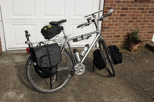
The bike I'm using is a Ridgeback Meteor. I've had it about 5 years and done somewhere between 8,000 and 10,000 miles on it. It's had quite a lot of modifications. It has racks and panniers front and rear. The odd post on the rear carrier is actually part of a camera tripod. I'm expecting to take quite a few pictures during the trip and this gives me the equivalent of a tripod without having to carry one. The pump and water bottles are pretty ordinary. The saddle bag is where the GPS kit travels. I described this equipment earlier in Mobile Devices. A speed/timer/distance computer mounted on the handlebars completes the measuring equipment.
Aside from the tripod mount on the back, the other major modification is a map table added to the handlebars. You can just see it above the handlebars in the picture. It's made from scrap MDF and aluminium and mounted on an old handlebar riser. Another tripod ball joint mounting means it can be repositioned easily. It's large enough to accomodate A4 sized printed maps which are protected from the weather inside a transparent Zip loc folder. I'm taking paper maps as well as the electronic version loaded into my Dell Axim.
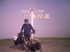
The ride starts at Land's End on Thursday May 11th and, not unnaturally, ends at John O'Groats on Friday June 9th. The route is as follows:
| Sector Distance | Total Distance | |||||
| Day | Date | Sector | Map | Bike | Map | Bike |
| Thursday | 11-May | Land's End to Par Sands | 70.70 | 71.90 | 70.70 | 71.90 |
| Friday | 12-May | Par Sands to Moretonhampstead | 57.60 | 58.58 | 128.30 | 130.48 |
| Saturday | 13-May | Moretonhampstead to Bridgwater | 60.90 | 61.94 | 189.20 | 192.42 |
| Sunday | 14-May | Bridgwater to Bristol | 59.98 | 61.00 | 249.18 | 253.42 |
| Monday | 15-May | Bristol to Bishop's Cleeve | 48.70 | 49.53 | 297.88 | 302.94 |
| Tuesday | 16-May | Bishop's Cleeve to Ironbridge | 59.70 | 60.71 | 357.58 | 363.66 |
| Wednesday | 17-May | Ironbridge to Culcheth | 70.24 | 71.43 | 427.82 | 435.09 |
| Thursday | 18-May | Culcheth to Kirkby Lonsdale | 72.22 | 73.45 | 500.04 | 508.54 |
| Friday | 19-May | Kirkby Lonsdale to Lazonby | 61.80 | 62.85 | 561.84 | 571.39 |
| Saturday | 20-May | Lazonby to Eskdalemuir | 50.90 | 51.77 | 612.74 | 623.16 |
| Sunday | 21-May | Eskdalemuir to Loanhead (Edinburgh) | 57.40 | 58.38 | 670.14 | 681.53 |
| Monday | 22-May | Present at W4A 2006 | 0.00 | 0.00 | 670.14 | 681.53 |
| Tuesday | 23-May | Loanhead (Edinburgh) to Brig O'Turk | 71.10 | 72.31 | 741.24 | 753.84 |
| Wednesday | 24-May | Brig O'Turk to Oban | 73.90 | 75.16 | 815.14 | 829.00 |
| Thursday | 25-May | Oban to Fionphort | 35.10 | 35.70 | 850.24 | 864.69 |
| Friday | 26-May | Iona and Staffa by boat | 0.00 | 0.00 | 850.24 | 864.69 |
| Saturday | 27-May | Carsaig Arches and Malcolm's Point | 37.80 | 38.44 | 888.04 | 903.14 |
| Sunday | 28-May | Fionphort to Tobermory | 66.30 | 67.43 | 954.34 | 970.56 |
| Monday | 29-May | Kilchoan to Malaig (inc Ardnamurchan Point) | 70.90 | 72.11 | 1025.24 | 1042.67 |
| Tuesday | 30-May | Ardvasar to Broadford (inc Elgol) | 45.46 | 46.23 | 1070.70 | 1088.90 |
| Wednesday | 31-May | Broadford to Uig | 58.52 | 59.51 | 1129.22 | 1148.42 |
| Thursday | 01-Jun | Uig to Glendale (inc An t-Aigeach and sides) | 54.53 | 55.46 | 1183.75 | 1203.87 |
| Friday | 02-Jun | Glendale to Broadford (inc Fiskavaig side) | 64.57 | 65.67 | 1248.32 | 1269.54 |
| Saturday | 03-Jun | Broadford to Applecross | 49.33 | 50.17 | 1297.65 | 1319.71 |
| Sunday | 04-Jun | Applecross to Kinlochewe (inc Alligin Shuas side) | 53.17 | 54.07 | 1350.82 | 1373.78 |
| Monday | 05-Jun | Kinlochewe to Camusnagaul | 47.23 | 48.03 | 1398.05 | 1421.82 |
| Tuesday | 06-Jun | Camusnagaul to Lochinver | 57.22 | 58.19 | 1408.04 | 1431.98 |
| Wednesday | 07-Jun | Lochinver to Rhiconich inc Oldshoremore side | 57.94 | 58.92 | 1465.98 | 1490.90 |
| Thursday | 08-Jun | Rhiconich to Tongue inc Cape Wrath side | 67.07 | 68.21 | 1533.05 | 1559.11 |
| Friday | 09-Jun | Tongue to John O'Groats inc Dunnet and Duncansby sides | 75.92 | 77.21 | 1608.97 | 1636.32 |
There are two values for each sector and total distance. I've noticed that my bike and my maps disagree by about 1.7% on distances. I'm not sure which is right, but I've listed both.
As you might expect, I'm hoping to raise some money for charity during this endeavour. I've raised money for a variety of charities by undertaking sponsored rides in the past. Usually, that has been as part of the UK Bike Week event. I've ridden to work to raise money. That might not sound like much but as I live in Winchester and work in Guildford, it's actually an 86 mile round trip.
For the End to End ride, I've decided to support two charities. One, Wessex Heartbeat, is local to the area of Hampshire where I live. It supports the cardiac unit at Southampton General Hospital. My wife Angela has been involved in events to raise money for them in past years, even organizing a major band concert in Bournemouth.
The other charity is national. The Royal National Institute for the Blind (RNIB) supports over 2 million people in the UK suffering from visual impairment. It seemed appropriate to support RNIB as, during the ride, I'm speaking at a conference about access to the Web for people with disabilities during the ride.
The abstract for my presentation, The Meaning of 'Life': Capturing Intent from Web Authors is available from the W4A2006 conference Web site.
If you'd like to make a donation to either of the charities I'm supporting, that would be fantastic. If you'd like to sponsor me for RNIB, there is an on-line sponsorship page that makes it really simple. If you are local to my home village of South Wonston, there are sponsorship forms for Wessex Heartbeat in the village shop and in the social club. In addition, both RNIB and Wessex Heartbeat accept individual donations on-line.
One of the great things about modern technology is its mobility. On my "End to End" trip I'm taking a mobile phone, a GPS unit and a hand held computer. These last two will allow me to view my route and my track. Most importantly, they'll let me recover from inevitable mistakes in my map reading. Here is a picture of the equipment.
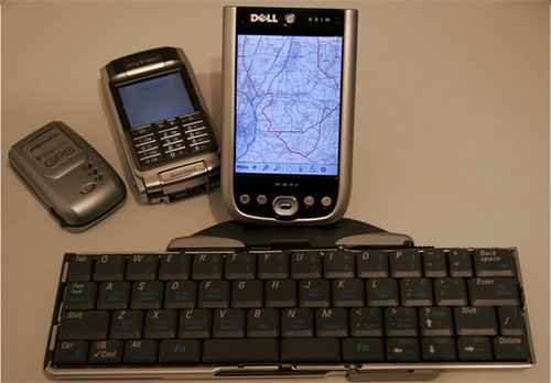
On the left is the GPS unit, a Globalsat BT338. Next to that is a Sony Ericsson P910 and taking centre stage behind the keyboard is a Dell Axim X51V PocketPC. The Dell is equipped with a high capacity battery. At the front of the picture is a ThinkOutside Universal Stowaway keyboard. Everything communicates via Bluetoth.
I've been using the GPS unit and the PocketPC to record my tracks during training rides. I have the Ordnance Survey maps for the UK together with MemoryMap software. This has enabled me to do all my route planning on my PC and then to download the results to the Dell. The GPS unit works with MemoryMap on the Dell to show me my location and to record my track. Amazingly, after a full day of riding, both the GPS unit and the PocketPC still have over 50% of their battery life intact. So long as I can recharge them each evening, I should be able to record the entire trip as I go.
I'm taking the keyboard to make it easier to write blog entries en route. I've tried various ways to get information onto this blog using the equipment in the photo. I wrote a simple blog client for my phone, which allows me to post text entries. I can also update using blogger's e-mail interface, but again, only for text. Photos are supported on some US networks, but not here in Europe at the moment. However, by using Flickr, I can post text and images together. It too has an e-mail interface for blogging. Images are stored on Flickr and referenced from blog entries that it forwards on to Blogger automatically. So I should be able to take photos with the camera on my phone, and post them here, together with a description of each days ride.
When I joined my present company, (Volantis Systems) one of the benefits was a sabbatical of four weeks to be taken after five years service. The company has been going over six years now, and the time has come to take advantage of that benefit. I've never had a sabbatical before. The attraction to me was to do something that wouldn't be possible with normal vacation time. After a lot of pondering I decided to cycle the length of mainland Britain.
If you know anything about the famous Land's End to John O'Groats routes, you'll know that a month is far more time than is necessary for the direct trip. Most people seem to manage the 900 or so miles in a couple of weeks. Since I have a whole extra two weeks, I decided to include some sightseeing in Scotland.
To complicate matters further, in the middle of the trip, I have to be in Edinburgh to give a paper at the W4A2006 conference. This conference focusses on issues concerned with access to the Web for people with disabilities. The result is a trip of more like 1600 miles, a much more suitable distance for four weeks in the saddle.


